Table Rock Master Plan Revision
AUGUST 2017
Description of Master Plan Land Classifications
JUNE 2017
FINAL MASTER PLAN UPDATE
2014 Table Rock Master Plan
App A Selected Land Classification Maps
App B Table Rock Master Plan All Parks Maps
App C Table Rock Master Plan All Supplements From 1976 Master Plan
MARCH 2014
Table Rock Lake Fact Sheet
FEBRUARY 2014
**Public Open Houses for Final Revised Table Rock Lake Master Plan**
Friday, March 7th 2014
2 P.M. to 7 P.M.
Dewey Short Visitors Center
4600 State Hwy 165
Branson, MO
Saturday, March 8th 2014
1 P.M. to 4 P.M.
Dewey Short Visitors Center
4600 State Hwy 165
Branson, MO
Volume 1
Final Table Rock Master Plan
Appendix A - Land Classification Maps Part 1, Part 2
Appendix B - Park Maps
Appendix C - Supplements from 1976 Master Plan
Volume 2
Final Environmental Assessment
Signed FONSI
Appendix A - Public Comments
Part 1 Scoping Reports/Scoping Comments
Scoping Report with Appedices A-E
Appendix F Parts 1, 2, 3, 4, 5, 6
Appendix G-H
Scoping Workshops After Action Report
Part 2 Draft Release Public Comments
Agency Letters
Oral Comments
Faxed Comments
Emailed Comments 1, 2, 3, 4, 5
Mailed Comments 1, 2, 3, 4, 5, 6, 7, 8
Appendix B - Local, State, and Federal Agency Coordination Letters
Part 1 Agency Scoping Letters
Part 2 Draft Release Agency Letters
Appendix C - Alternatives Maps
Selected Alternative Map Index
Maps 1, 2, 3, 4, 5, 6, 7, 8, 9, 10, 11, 12, 13, 14, 15, 16, 17, 18, 19, 20, 21, 22, 23, 24, 25
Alternative 1 Maps 1, 2
Alternative 2 Map Index
Maps 1, 2, 3, 4, 5, 6, 7, 8, 9, 10, 11, 12, 13, 14, 15, 16, 17, 18, 19, 20, 21, 22, 23, 24, 25
Alternative 2A Maps
Alternative 2B Maps
Alternative 2C Maps
Alternative 2D Map Index
Maps 1, 2, 3, 4, 5, 6, 7, 8, 9, 10, 11, 12, 13, 14, 15, 16, 17, 18, 19, 20, 21, 22, 23, 24, 25
Alternative 3 Maps 1, 2
Alternative 4 Maps 1, 2
LINKS: 1976 TABLE ROCK MASTER PLAN (3 Parts)
(1) 1976 Table Rock Master Plan Supplements; (2) 1976 Table Rock Master Plan Main Text; (3) 1976 Table Rock Master Plan Plates (Maps)
AUGUST 2013
Public review period now through August 30th. Comments must be received by August 30th to be included as part of the draft master plan review.
Comment Form (PDF)
Table Rock Master Plan Fact Sheet (PDF)
Comments may be submitted via mail, email, fax or the project website with attention to: Chief, Environmental Branch, Planning and Environmental, USACE, Little Rock District, P.O. Box 867, Little Rock, AR 72203. Fax: (501) 324-5605,
Email: M4TRMP@usace.army.mil
Website: Table Rock Master Plan Revision
JULY 2013
Draft Master Plan, Environmental Assessment, FONSI, and Park Plates
Draft Alternative 1 Plates
Draft Alternative 2 Plates
Draft Alternative 2a Plates *Plates 2a, 2b, and 2c only show affected areas*
Draft Alternative 2b Plates
Draft Alternative 2c Plates
Draft Alternative 2d Plates
Draft Alternative 3 Plates
Draft Alternative 4 Plates
**Public Open Houses for Draft Master Plan Release**
We are asking the public to drop in at any time during the following times and at the locations listed below. We will be showing a video run on 20 minute intervals; Corps personnel will also be available to answer questions during this time.
Wednesday, August 14th 2013
Noon to 4PM and 6 to 8PM
Dewey Short Visitors Center
4600 State Hwy 165
Branson, MO
Thursday, August 15th 2013
Noon to 4PM and 6 to 8PM
Shell Knob United Methodist Church
25682 State Hwy YY
Shell Knob, MO
Friday, August 16th 2013
Noon to 4PM and 6 to 8PM
Table Rock Gathering Hall, Kimberling City
11 Oak Drive
Kimberling City, MO
Saturday, August 17th 2013
9AM to 3PM
Dewey Short Visitor Center
4600 State Hwy 165
Branson, MO
JUNE 2013
National Recreation Strategic Plan
Comparison of No Change/No Action Alternative One to Proposed Alternative Two Land Classifications
MAY 2013
Focus Group Presentation
FEBRUARY 2013
Table Rock Master Plan Scoping Report (3 Parts)
Table Rock Master Plan Scoping Report - Final Report and Appendices A-E
Table Rock Master Plan Scoping Report - Appendix F : Public Comments
Table Rock Master Plan Scoping Report - Appendices G-H: Workshop Materials, Agency Comments and Media Coverage
JANUARY 2013
Table Rock Lake FAQs on Moratorium
NOVEMBER/DECEMBER 2012
November/December 2012 Scoping Workshop Comment Card
Comments may be submitted via mail, email, fax or the project website with attention to: Chief, Environmental Branch, Planning and Environmental, USACE, Little Rock District, P.O. Box 867, Little Rock, AR 72203. Fax: (501) 324-5605,
Email: M4TRMP@usace.army.mil
Website: Table Rock Master Plan Revision
General Information
The Army Corps of Engineers (USACE), Little Rock District, is revising the Table Rock Lake Master Plan. The Master Plan guides the management of the government lands around the edge of the lake. The Master Plan affects future management of natural resources and recreational opportunities to ensure the sustainability of Table Rock Lake.
The Master Plan revision will set the stage for a later update of the Shoreline Management Plan, which is how the vision of the Master Plan is implemented. This is your opportunity to let USACE know how you would like the lake to be managed for the future.
The planning process will include an analysis of potential effects on the natural and social environment, including fish and wildlife, recreational opportunities, economics, land use, cultural and historic resources, aesthetics, and public health and safety.
About Table Rock Lake
Table Rock Lake is a man-made lake or reservoir located in southwest Missouri and portions of northwestern Arkansas and was formed in 1958 by construction of a dam on the White River near Branson, MO. The lake is about 43,000 acres in size with over 745 miles of shoreline. The lake provides many recreational opportunities, fish and wildlife habitat, and is a popular location for vacation and retirement homes.
During periods of high water events and flooding, Table Rock Lake is operated in conjunction with other lakes in the basin to prevent damage along the White and lower Mississippi Rivers. The dam also generates hydropower electricity.
What is a Master Plan?
A Master Plan is the guidance document that describes how the resources of the lake will be managed in the future. The Master Plan provides the vision for how the lake should look in the future. The Master Plan does not address the details of how and where shoreline use permits may be issued, however, it does set the stage for implementation of the shoreline management program. After the Master Plan is revised, the Shoreline Management Plan would be revised to be consistent with the goals identified in the Master Plan when funding becomes available.
Development of the revised Master Plan will include consideration of:
• Regional and ecosystem needs
• Project resource capabilities and suitability for various purposes
• Public interests and desires
The Table Rock Lake Master Plan Update main objectives are:
• To make maximum use of the resources of the lake within the current policies and guidelines of the Corps of Engineers
• Accommodate current and projected use patterns with maximum efficiency
• Identify and protect cultural and natural resources
• To attract maximum participation by the general public and local government in project development management.
Why Revise the Table Rock Lake Master Plan?
The current Table Rock Lake Master Plan was developed over 30 years ago and original estimates of future population and land use do not align with current demographics. For example, the current Master Plan estimated that the lake would see approximately 20 million visitors annually by the year 2020; however, current visitation is already at 40 to 50 million visitors annually for recreational activities. The Master Plan revision will classify the government lands around the lake based on environmental and socioeconomic considerations, public input, and an evaluation of past, present, and forecasted trends.
Lands may be classified into one of these categories:
• Project Operations: lands required for the dam, spillway, offices, and other areas used solely for the operation of the reservoir.
• High Density Recreation: lands acquired for project operations and designated for use as parks or other areas for intensive recreational activities by the visiting public. Private floating facilities would not be allowed in these areas.
• Environmentally Sensitive Areas: lands designated for areas where scientific, ecological, cultural, or aesthetic features have been identified. These areas are managed to protect their environmental resources.
• Multiple Resource Management Lands: This classification allows for the designation of a predominant use with the understanding that other compatible uses may also occur on these lands, these additional uses may include:
• Low Density Recreation: lands classified for use for activities such as hiking trails, primitive camping, limited lake access points, and other similar low density activities by the visiting public. Private floating facilities may be permitted in these areas in accordance with the lake Shoreline Management Plan
• Wildlife Management: lands allocated as habitat for fish and wildlife, and are generally open for hunting and fishing.
• Future/Inactive Recreation Areas: Lands intended for recreation, but which were never developed or have been closed.
• Vegetative Management: Lands designated for stewardship of forest, prairie, and other native vegetative cover.
• Water Surface: For those projects that administer a surface water zoning program, this will be included in the Master Plan revision process.
• Restricted: Water areas restricted for project operations, safety, and security purposes.
• Designated No-Wake: To protect environmentally sensitive shoreline areas, recreational water access areas from disturbance, and for public safety.
• Fish and Wildlife Sanctuary: Annual or seasonal restrictions on areas to protect fish and wildlife species during periods of migrations, resting, feeding, nesting, and/or spawning.
• Open Recreation: Those waters available for year round or seasonal water-based recreational use.
These land classifications are established in the Master Plan and will guide the future update to the Shoreline Management Plan, which implements the Master Plan and provides the policies under which shoreline use permits may be issued for boat docks and/or shoreline vegetation modification.
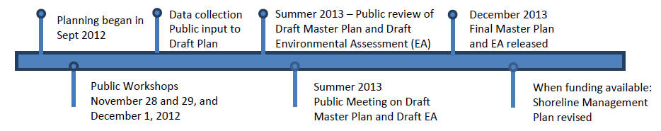
Project Timeline
How to view maps in Adobe:
In Adobe use the Select and Zoom tools to navigate around the map.
Use the hand tool to pan around the map.
Use the Marquee Zoom tool to draw a box and zoom to selected area of interest.
Change the zoom % to quickly zoom to entire map at 10% or to 400% for the most detail.