Little Rock District operates lakes in the White, Arkansas, and Little River Basins. In the White River Basin: Beaver, Table Rock, and Bull Shoals Lakes are on the main stem of the White River; Norfork Lake is on the North Fork of the White River (North Fork River) which flows into the White River downstream of Bulls Shoals Lake. Clearwater Lake is in the Black River Basin; and the Black River drains into the White River near Newport, Arkansas. Greers Ferry Lake is on the Little Red River which flows into the White River near Georgetown, Arkansas. The White River flows into the U.S. Army Corps of Engineers, Memphis District and empties into the Mississippi River. Blue Mountain Lake is on the Petit Jean River. Nimrod Lake is on the Fourche La Fave River. The Petit Jean and Fourche La Fave Rivers drain into the Arkansas River. There are 12 locks and dams on the Arkansas River (including the Arkansas Post Canal) and one lock and dam on the White River. DeQueen Lake is on the Rolling Fork River. Gillham Lake is on the Cossatot River. Dierks Lake is on the Saline River. The Rolling Fork, Cossatot, and Saline Rivers empty into the Little River, which drains into Millwood Lake.

Figure 1. Major River Basins in Little Rock District
The Corps of Engineers is organized by river basins. Lakes in the Ouachita Basin are operated by Vicksburg District.
The National Data Base of Large Dams is available at nid.sec.usace.army.mil. There you can search by name or use an interactive map to find a dam and some basic information about a dam’s owner, size, hazard potential, and responsible government agency.
Visit www.swl-wc.usace.army.mil or use the App. The app can be found by searching “USACE Little Rock” in the Google Play Store or the Apple App Store.
No, Little Rock District does NOT make lake release decision based on rainfall forecasts. Rainfall forecasts for the region have not achieved the required accuracy to safely operate to rainfall forecast. There are two common undesirable outcomes of operating to forecast: first, is the loss of conservation water; and second, is the inducing of additional flooding downstream.
One chilling example of why Little Rock District does not prerelease happened in the spring of 2017. A historic rainfall was predicted over Northwest Arkansas. Based on the National Weather Service (NWS) rainfall forecast, engineers forecasted record releases from Beaver Dam. The storm produced rainfall similar to the NWS forecast, but was centered about 100 miles northeast of where predicted (near Cabool, Missouri). Instead of Beaver Lake; Table Rock, Norfork, and Bull Shoals Lakes received near record inflows from the storm. If the district had made pre-releases based on forecast those releases would have made flooding worse along the White River from Branson, MO to the river’s confluence with the Mississippi. Rainfall forecasts can be inaccurate in terms of rainfall amount and location.
In some parts of the country, current forecast accuracy combined with the configuration of lakes and the topography have presented conditions where release decisions can account for rainfall forecasts. The district is watching the state of the forecasting science for future developments that may make operating to forecast possible for our region.
The answer depends on how the idea of pre-release is defined. Little Rock District aggressively releases water from flood pool as soon as downstream conditions allow. However, Little Rock District does not make release decisions based on a rain forecast. Pre-releasing for additional storage in conservation pool is also not a consideration for flood risk management; conservation storage belongs to hydropower and water supply users. Released water could negatively impact downstream stakeholders. Please see the questions “Do Little Rock District engineers make release decisions based on rainfall forecast?” or “What is seasonal pool?” for more information on related topics.
Analysis of over 80 years of hydrologic data has shown that flood pools usually fill because persistent, repeated rain storms do not allow enough time to evacuate flood storage between events. In other words, flood storage is almost always filled by several smaller storms rather than by one large storm. So, using a long-term perspective, the District prepares for the future by making releases whenever possible when flood storage is in use.
The Corps maintains a website at www.swl-wc.usace.mil and an app for Android and Apple operating systems. Real-time data, project operating data, and daily reports are a few of the items available. Personnel make reoccurring presentations to local elected officials and emergency managers from jurisdictions impacted by lake operations, usually every other year. Presentations are also available to various stakeholder groups at their request. The Water Management team answers numerous phone calls and electronic correspondence from the general public, media, and congressional staffs throughout the year. If you would like to arrange a presentation or get our app; visit section, “I have a question not answered by this FAQ.”
Each lake operated by Little Rock District derives its operational authority from federal law. After the Great Flood of 1927, Congress passed the Flood Control Act of 1928 and the Corps began designing lakes and their operational rules to reduce downstream flood risk. Congress has modified the authorities at various intervals since the first Flood Control Act to reconfigure planned lakes, and include additional missions such as hydropower, navigation, water supply, and/or ecological for various lakes. The lakes were designed and are operated to meet the goals set forth by Congress. The Water Control Plan for each basin is described in each basin’s Master Manual and further detailed in each lake’s the Water Control Manual. As our nation’s understanding of the complex stakeholder impacts of lake’s operational plans has evolved, permanent changes to a Water Control Plan have been made subject to National Environmental Protection Act (NEPA) processes. Water Control Manuals are updated about once a decade. The updated process is usually limited to documenting improvements in forecasting tools and updating hydrologic history, but sometimes major changes are incorporated; like congressionally mandated alterations to the plan or recent results of a NEPA guided study. There are a number of questions below addressing some of the complexities involved with making changes to a Water Control Plan in the section: “I have a great idea for changing the lake near me, what could go wrong?”
Heavy rains can occur any time of year in this region. Storms that occur when leaves are off the trees (November through March) tend to produce the highest portion of runoff. For example, if a 3-inch rain falls in January, 2 inches of the rainfall may immediately runoff to the lakes; but the same storm might have 1 inch of runoff in July because of increased evaporation and transpiration (the trees drinking up the rainfall). As a general rule, significant runoff events start about deer hunting season (mid-November) and do not fully taper off until after Memorial Day (late May). Just because less water runs off during the growing season doesn’t mean floods cannot happen in the summer. For most rivers in the area, some of the top ten runoff events were caused by summer tropical storm systems. Activities, like farming, running a business, or living in a floodplain is a risk. Read “I live near a large lake, should I buy flood insurance?” to learn more about if flood insurance would help protect your investments from flood risk.
In some cases, lakes that are not designed or operated to reduce flooding can increase the local flood risk. Little Rock district lakes are designed and operated to reduce flooding; however, the lakes are not intended to prevent all flooding. Lakes have limitations that can be exceeded by extreme events. Therefore, property owners should be judicious in how they develop land near or downstream of a lake. Little Rock flood risk management lakes do reduce the frequency of floods, and when floods do occur they are not as severe as would have been without the dam. But there will still be occasions when significant floods occur both upstream and downstream of these dams. Planting crops on land that floods occasionally might be profitable in the long run; but building a home or business on the same might not be so profitable. Activities, like farming, running a business, or living in a floodplain is a risk. Read “I live near a large lake, should I buy flood insurance?” to learn more about if flood insurance would help protect your investments from flood risk.
Flood risk management lakes work by capturing runoff in their flood pools during heavy rain. After rivers downstream begin receding, water is released in a controlled fashion following a pre-determined operating plan. Without the lakes, all the runoff would flow downriver at the same time. Flood crests would rise higher and spread over more land, thus causing more damage and possibly loss of life. The water stored in the flood pool must be evacuated as quickly as downstream conditions permit without causing additional flooding. This aggressive evacuation prepares the lake for the next storm event. Repeated rains represent a serious difficulty to engineers managing flood risk reduction lakes. Engineers are not always able to release all the captured water from one rain event before the next rain event occurs. This can cause the lake levels to rise with each new rainfall. Releasing huge volumes of water that can be captured in flood pool can take many months especially if the area receives repeated storms during the emptying period.
A decision to build near a water body is complex. Two important considerations are the flood risk of the site and the erosion risk of the site. FEMA maintains flood risk maps at msc.fema.gov that might be helpful in understanding the risks first consideration. Your local floodplain manager (county or city official) will likely be able to give you further guidance about local risks, local rules, and locally required permits related to building in a jurisdiction floodplain. Erosion risks of properties near water are complex. Unlike common statements in science programs, most rivers and streams in the Little Rock district do not take "millions of years" to move. The outside of bends of rivers with silty or sandy soils can naturally move several feet a year. Waves from wind and boats can cause banks in a lake to move, too. The Corps does not have authority to protect private properties when erosion threatens homes or businesses.
The Corps does not have authority to protect private properties when erosion threatens homes or businesses. When authorized, the Corps has some capacity to assist local and state governments through an emergency stream bank protection program aimed to protect public infrastructure; however, no similar program exists for private properties.
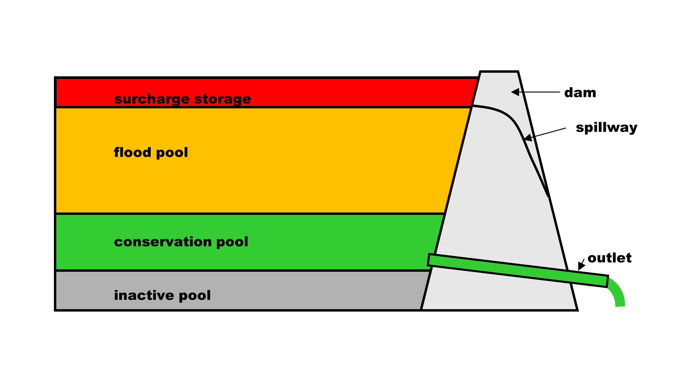
Pool refers to a volume of storage set aside in a lake for a specific purpose. The volume of a pool is measured in acre-feet.
The types of pool in flood control lakes are inactive pool, conservation pool, seasonal pool, flood pool, and surcharge pool. Arkansas River locks and dams are limited to one kind of pool: navigation pool.[1]
Seasonal pool refers to changes in conservation pool target(s) at a lake based on seasonal flood risk, water supply, and ecological needs at a particular lake. Generally, the seasonal pool raises the conservation pool elevation in the early summer and drops the top of conservation pool elevation target back down by autumn. The specific reason for season pool varies by lake, but generally the seasonal pool is designed to enhance cover for young fish in the lake, provide additional storage for summertime ecological releases, and/or aid mosquito control.
Figure 2. Typical types of storage in a FRM lake
The inactive pool is the volume of water at the bottom of the lake that is difficult to use because of its depth. The water in the inactive pool is not considered usable, but can be used in drought emergency at the discretion of the district commander. This volume is sometimes set aside to accommodate sediment deposition in the lake.
Conservation pool is the volume of water conserved after a flood to be used for water supply and other consumptive uses during periods of dry weather. Hydropower is often the largest use of conservation pool storage, although in some lakes municipal water supply is the largest part of the conservation storage. The conservation pool volume is calculated to meet the anticipated water demands required during the drought of record. The drought of record is the longest, severest drought recorded for the lake.
Seasonal pool refers to changes in conservation pool target(s) at a lake based on seasonal flood risk, water supply, and ecological needs at a particular lake. Generally, the seasonal pool raises the conservation pool elevation in the early summer and drops the top of conservation pool elevation target back down by autumn. The specific reason for season pool varies by lake, but generally the seasonal pool is designed to enhance cover for young fish in the lake, provide additional storage for summertime ecological releases, and/or aid mosquito control.
Flood pool is the storage set aside for storing flood waters and releasing them to reduce downstream flood peaks. The highest priority of Little Rock district flood risk management lakes is to evacuate the flood storage at the earliest possible time. Explore: “How do lakes reduce flooding?” and “Do lakes prevent flooding?” for more information regarding flood pool operations.
Surcharge storage is extra storage created by operation of an overflow spillway. On a lake with a gated spillway, as the gates open the top of gate rises giving a bit more storage space for the flood – this operation maximizes the storage while optimizing the release. On a lake with an ungated spillway, the spillway only flows if the lake rises above the spillway. Surcharge storage is the extra volume stored in the lake due to the rise above the spillway.
Navigation pool is a special kind of conservation pool, where the water is conserved for maintaining minimum navigation depths along the river. The only kind of pool on most of the MKARNS locks and dams is navigation pool.
Regulating stage is the target stage at a location downstream of a dam. The water in the river at a regulating target location will be a combination of water released from the upstream dam(s) and the runoff -from rains downstream of the dam. The regulating stage location needs to be close enough to the dam that in the event of rain below the dam, closing the gates can usually decrease the experienced stage.
The most common reason a river is below regulating stage is that there has not been much rain recently. The lack of rain means there has not been significant runoff below the dam and that the lake is probably in a conservation operation. Sometimes, the dam will still be making flood risk management releases, but downstream runoff is low; so the combination of the two does not add up to enough flow to meet regulating stage.
The most common reason a river is above regulating stage is that there has been significant rain downstream of the dam; in most cases the releases from the dam have been significantly curtailed but runoff between the dam and the regulating stage location is causing the regulating stage to be exceeded.
Usually, if a river is above regulating stage, then the upstream lake(s) releases have been reduced to their minimum release. The minimum release is designed to meet minimum ecological and/or water supply requirements in the channel directly downstream of the dam. In the case of hydropower plants, the minimum release is sometimes called firm power because it represents the firm minimum power production the plant can be counted on to produce.
In unusual cases, the releases from the dam are surcharge releases. Surcharge releases are highly modified peak flood releases made when the lake has run out of flood pool storage. Further reading about surcharge operations is available under the “What is surcharge pool?”
Stage is an arbitrary measure of depth at a point along a river. The “zero” stage is often the low point the water reached in the summer when folks first starting measuring the river’s depth at that location. Engineers will often refer to the elevation above sea level at “zero” measurement of stage as the “gage datum.”
A gage datum is the value that is added to the stage measurement to calculate the elevation of the water above sea level per a prescribed elevation datum. Datum refers to a single element of data, often the “zero” value of a data set. At a stage gage, the datum refers to the elevation when the staff gage reads zero. See the question, “What are MSL, NGVD, or NAVD?” for a discussion about elevation data.
Water surface elevation is the level, above sea level, of the water’s top at a point along a river or lake. See the question, “What are MSL, NGVD, or NAVD?” for more information about different ways of measuring elevation.
Stage is usually the measured height from a local low water reference, but water surface elevation is the orthometric height (generally understood as the height above sea level) of the water’s top. Stage gages usually report a gage datum, which is the elevation when the stage is zero. So, to turn a stage into a water surface elevation one may add the gage datum to the stage.
A few regularly used acronyms by Little Rock water management engineers are FRM, QPF, WCM/WCP, ACE, MSL, NAVD, NGVD, USACE, SWPA, and MKARNS. Units of measurement like c.f.s. (cfs), d.s.f. (DSF), MW are regularly found in Little Rock water management documents. See following questions for more details about each.
ACE, pronounced “A-C-E,” stands for Annual Chance of Exceedance. The Annual Chance of Exceedance is the statistical likelihood that an event larger than a given size will occur during a given year. To say, “. . . that flood was a 1 in 100 ACE,” is more precise than saying, “that was a one-hundred year flood.”
Acre-feet is how engineers measure the volume of storage in a large lake. One acre-foot is the volume of water required to flood an acre of land one foot deep. There are 325,800 gallons in an acre-foot. A flow of 1 d.s.f. (average of 1 c.f.s. per day) will fill about 2 acre-feet of storage. See below for explanations of c.f.s. and d.s.f.
c.f.s. (cfs is sometimes shown in our online reports) stands for cubic-feet-per-second. A cubic foot of water per second is almost 450 gallons of water per minute. For a frame of reference a shower head delivers about 2 gallons of water per minute, or about 0.004 c.f.s. The Buffalo River at St. Joe typically flows at about 200 c.f.s. on July 4th, the White River at Newport typically flows at about 15,000 c.f.s. on July 4th, and the Mississippi River at Memphis typically flows about 400,000 c.f.s. on July 4th.
DSAC, pronounced, “DE-sack,” stands for Dam Safety Action Classification. A team of engineers and scientists do a detailed inspection and analysis of each USACE’s approximately 700 dam for safety risks. Each dam is given an urgency score from 1 to 5 (I to V). The DSAC I rating is given to a dam that is actively progressing toward failure. The DSAC III rating is given to dams that are considered to have issues of inadequacy or combination of failure consequences that are deemed to be a moderate risk. The DSAC V rating is for a dam considered to be meet all essential agency guidelines and the residual risk is considered tolerable.
d.s.f. (DSF as sometimes shown in our online reports) stands for day-second-foot. A d.s.f is the average cubic-feet-per-second (c.f.s.) that passes a location in 24 hours. Stated another way, a day-second-foot is a volume of water to pass a location in one day. d.s.f. is often described as cfs/day in engineering text books. See above for an explanation of c.f.s.
FRM, pronounced “F-R-M,” stands for Flood Risk Management. Flood Risk Management is the primary mission of Little Rock District’s dams except for the locks and dams on the Arkansas River Navigation System. The Lock and Dams primary mission is holding a navigation pool.
MKARNS, pronounced “em-karns,” stands for McClellan-Kerr Arkansas River Navigation System. Navigation systems are also referred to as marine highways. The 455-mile long system begins at the entrance of the White River into the Mississippi River, passes through a navigation canal (the Arkansas Post Canal) into the Arkansas River, continues upstream into Oklahoma to the mouth of Verdigris River, and ends on the Verdigris at the Port of Catoosa, Oklahoma.
MSL, NGVD, and NAVD are systems for measuring orthometric heights (elevation). In simple terms, these systems measure the height above sea level. MSL stands for Mean Sea Level. NGVD stands for National Geodetic Vertical Datum of 1929, most elevations used by Little Rock District are reported in this datum because it was the prevailing elevation datum when the lakes were built. NAVD stands for the North American Vertical Datum of 1988, it is considered more accurate than NGVD. Elevations on reported in this FAQ and other Water Management Documents are reported in the construction datum, usually NGVD. The difference between NAVD and NVGD is generally less than a half of foot in Little Rock District. The website https://www.ngs.noaa.gov/TOOLS/Vertcon/vertcon.html can be consulted for more detail on differences between the two orthometric measuring systems.
MW stands for MegaWatt. Megawatts are used to describe the amount of power produced at hydropower plants in Little Rock District. A watt is a unit of power. A megawatt is one million watts. The amount of water release required to generate a megawatt varies based on lake level and the configuration of the turbine.
N.M. stands for Navigation Mile as measured from the start of the navigation system (marine Highway). R.M. stands for River Mile as measured from the mouth of the river. River Miles measure how much further the water will flow before entering another more significant body of water, and Navigation Miles measure distance along the marine highway indicating how much further a boat will have to travel to exit the highway. There is general correspondence between the two measurements on the Arkansas River itself, but because the navigation route doesn’t always follow the Arkansas River (like using a canal or a different river) the N.M. and R.M. distances may not match exactly for the same location.
QPF, pronounced “Q-P-F,” stands for Quantitative Precipitation Forecast. The QPF is a future rain estimate developed by the National Weather Service. Little Rock District engineers monitor the QPF closely for planning purposes, but do NOT make release decisions using the QPF. Please see the question “Do Little Rock District engineers make release decisions based on rainfall forecast?” for more information.
SWPA, pronounced “SWAP-uh,” stands for Southwestern Power Administration. SWPA is responsible for marketing the electric power generated by Little Rock District Dams.
SWL, pronounced, “S-W-L,” stands for Southwest Division, Little Rock District.
USACE, pronounced, “YOU-sayce,” stands for United States Army Corps of Engineers.
WCM stands for Water Control Manual. The acronym is rarely used in speech, but is common in written correspondence. Each lake has a manual that sets the context by which the lake is to be operated. Each basin has a master manual to which each WCM is an appendix.
WCP stands for Water Control Plan. The acronym is rarely used in speech, and is usually replaced by WCM in written correspondence. Each lake has a plan that dictates the constraints by which the lake is to be operated. Each basin has a master manual to which each WCM is an appendix.
The primary reason a specific Little Rock District Lake was built was because Congress authorized the building of the lake. Congress generally authorized lakes in Little Rock District either for flood risk reduction or navigation. Other authorized purposes were sometimes included in the law(s) calling for the construction and operation of district lakes: those authorizing purposes may include: hydropower, water supply, or minimum flow. In some cases recreation and/or fish and wildlife authorizations have been passed by congress or assigned by executive order. See FAQ: “Specific Questions about Specific Projects” for more information about a particular lake in Little Rock District.
When a lake is using flood pool storage the first consideration is how much water can be released safely. The downstream safe targets are outlined in each lake’s water control plan.
The use of hydropower turbines at Little Rock district projects are determined by three general criteria: (1) availability of water, (2) need for power, and (3) ecological needs. While most hydropower projects in the district are operated by SWPA, some hydropower projects are not operated by federal interests. The non-federal projects are not managed in any way by Little Rock District.
For White River Hydropower Projects:
When the lake elevation is above top of conservation pool, Little Rock District engineers provide Southwestern Power Administration (SWPA) release requirements to meet flood risk management mission constraints. Usually, SWPA will make those releases through the turbines, but if the turbines cannot make some of the release, then USACE will make flood risk management releases through other outlets. If the lake elevation is below top of conservation pool, then releases are usually dictated by SWPA based on power demand needs. In both cases, when water is above or below top of conservation pool, releases may be made in a particular manner to maintain appropriate dissolved oxygen, temperature, and/or minimum flow targets downstream of the dam. A strength of the White River hydropower configuration is that it can be turned on and off at a moment’s notice making the plants very useful for supplying renewable, clean power when it is most critically needed in the region.
For Arkansas River Hydropower Projects:
The Arkansas River Hydropower Projects are “run-of-river.” They can only be operated if there is flow within appropriate ranges to spin the turbines. The flow can be too low or too high for operation. If there is a need for electricity and there is appropriate flow in the river, then releases are made through the turbines; otherwise, required releases are made through other outlets. The hydropower plants at Ozark and Dardanelle Lock and Dams are the only projects in the district that are hybrid run-of-river projects because each have a small storage allotment in the upstream pool to let it operate on demand for a short period of time without sustaining flows from the river.
Do SWPA and USACE work together on releases from the dams?
Yes. Both USACE and SWPA are following the missions entrusted to them under the law and coordinate regularly to verify release plans are meeting their respective missions.
Hydropower plants are complex machines and have to be taken off-line from time to time for maintenance and repairs. Some repairs require significant design and construction time frames. The dams in Little District are designed to meet flood risk management mission requirements without using hydropower turbines.
Each user of water supply is allotted a portion of the storage in the lake. It is the responsibility of the users to decide how and when to use their allotments. The District tracks the inflow and usage of users and sends a notice to a particular user when an allotment is at risk of being depleted.
Little Rock District does NOT regulate lakes for recreation. Recreation is an ancillary benefit of the lakes and recreation issues do NOT enter into Little Rock District daily water management decisions. The District does NOT have legal authority to manage any of the District’s lakes for recreation. The Corps is bound by law to follow the Water Control Plan for how each lake and system of lakes is operated. Rarely, special operations are undertaken to support a community recreation events if authorized missions can still be met; see “Can Little Rock District deviate from a Water Control Plan to help someone?” to learn more about operational deviations.
No. The navigation locks and dams along the Arkansas River in Arkansas do not have the storage capacity to modify or reduce floods. Flood Risk Reduction along the Arkansas River is primarily the provided by operations of lakes west of Arkansas in Oklahoma and Kansas. Two flood control lakes in Arkansas, Nimrod and Blue Mountain, have a small impact along the main stem of the Arkansas River.
Living near or directly downstream of a lake does NOT protect you from all floods. The flood insurance program is administered by the Federal Emergency Management Agency (FEMA). FEMA maintains flood risk maps at msc.fema.gov. As of early 2020, that site said: “Whether you are in a high risk zone or not, you may need flood insurance because most homeowners insurance doesn't cover flood damage. If you live in an area with low or moderate flood risk, you are 5 times more likely to experience flood than a fire in your home over the next 30 years. For many, a National Flood Insurance Program's flood insurance policy could cost less than $400 per year.”
There are lots of good ways to manage a lake for a given purpose, the challenge is making sure one change does not hurt someone else that depends on the same lake. Short-term gains can have tragic long-term consequences. The following questions reflect the most commonly requested management changes at Little Rock District Lakes.
Managing a lake to a near constant level is good for lakeside businesses and homes, especially activities related to docks. However, there are a number of negative impacts from managing to keep a lake level constant. Most importantly for FRM lakes is that if the lake is kept at the same level all the time, flood waters cannot be captured and then released slowly after the downstream flood wave has past. Additionally, a lake managed for a constant water surface cannot be drawn down for conservation pool uses like hydropower and water supply. For example, the White River hydropower plants are used to produce on-demand hydropower, which is really nice at 4pm on a hot summer afternoon when everyone is running their air conditioners. Holding a lake at a constant level can also have negative impacts to fish spawns. Some lakes are intended to maintain a stable water surface, but Little Rock District Lake’s primary mission of flood control makes such management impractical; the difficulty in maintaining such a goal is compounded by demands on conservation storage.
The idea to fill a lake’s flood pool in the late spring for summer time consumption has the benefit of increasing the water supply for various users. This question is common during times of drought and among new residents that have been accustom to living near lakes operated to capture snow melt for consumption and springtime flood reduction. The climate and topography of Little Rock District do not support capturing a springtime snow melt flood. Lakes in this region have to be managed with the long-term perspective that recognizes that summer tropical storms and hurricanes have produced damaging floods. Going into the summer tropical storm season with flood pool storage reduces the flood protection until the flood pool can be recovered; therefore flood waters should be discharged as soon as downstream conditions allow. A secondary negative impact of a high lake level is that some recreational opportunities can be compromised.
When flood pool storage is reallocated to another purpose then there is not as much storage for storm water runoff. If the other purpose is not aggressive about using water from the conservation pool, then the lake may surcharge more frequently. Surcharge releases happen when the flood pool is exhausted. See the questions: “What is flood pool?” and “What is surcharge pool?” for more information on flood and surcharge operations.
This question could occur between any two conservation users, and this question does occasionally get presented by one user asking for another user’s conservation pool allocation where there is no hydropower. Hydropower’s allocation of conservation pool is the most commonly requested allocation because it tends to be largest in the lake. The users of the conservation pool pay for the cost to maintain the conservation pool. They make economic decisions that impact their customers’ rates based on knowing a guaranteed amount of water will be available each season. Sometimes users will buy and sell a portion of their water allocations, but often the implications reach far beyond the immediate transaction. Transferring an allocation between users can have far reaching economic impacts and should not be undertaken lightly. See the question: “What is conservation pool?” for more about conservation pool.
Sometimes hot, dry summers naturally cause the conservation pool to be very low entering the rainy season. Starting the winter with a low lake level makes managing the winter and spring runoff easier; however, the conservation pool is designed to supply water through drought. The most severe droughts in the region spanned multiple years. Intentionally releasing water intended for conservation uses could result in there not being enough water for a drought.
Targeting a lower downstream stage, or regulating stage, during growing season could open up thousands of acres of possible farmland below some of Little Rock District Lakes. The farmland could dry faster after the rains and the crops planted earlier, but in most cases the crops would not be less likely to be impacted by flooding. If the regulating stage is lowered, the result is like putting a wash cloth over a bath tub drain, the tub still drains, but more slowly. Likewise, the lower regulating stage means the lake empties its flood pool more slowly. The slower emptying has two negative consequences: (1) the lake is more likely to surcharge, and (2) the river is vulnerable to flooding from downstream storms for a longer period of time. If the flood pool is partly full, a summer storm is more likely to fill the lake and cause large surcharge releases. If the river stays partly full most of the summer, then the local thunderstorms push the river out of its banks more often.
The target flow or target stage will depend on what and how the fishermen are fishing. If the target flow is lower than the regulating stage then there could be more frequent and severe flooding as a result. If the target flow is more than water supply/hydropower uses operating for recreation could cause the water to run out too soon, leaving people thirsty and without air-conditioning in the heat of the summer. In some cases targeting a particular recreational stage can have negative impacts to other sportsmen or farming concerns along the river. For example, the ideal release for boaters is rarely ideal for wade fishermen. Targeting one recreational group, like wade fishermen, often limits the opportunities of another group, like boaters. Recreational operations are lower priority than flood risk management and hydropower. Recreational operations have complex impacts beyond the targeted sport.
The optimal water level depends on how and what the hunter is hunting. Typically, duck hunters want high lakes and high rivers to flood the trees. Typically, deer hunters want low lakes and low rivers to prevent their hunting zone form being closed or ensure that their hunting location is accessible. The Little Rock Water Management Office will often receive calls from hunters on the same day asking for opposite operations. The lakes are managed, foremost, to reduce flood risk. If the target flow is lower than the regulating stage then there could be more frequent and severe flooding as a result. If the target flow is more than water supply/hydropower would utilize, operating for recreation could cause the water to run out too soon, leaving people thirsty and without air-conditioning in the heat of the summer. In some cases, targeting a particular recreational stage can have negative impacts to other economic concerns along the river. Targeting one recreational group often limits the opportunities of another group. Recreational operations are lower priority than flood risk management and have complex economic impacts beyond the targeted sport.
Lake operational plans impact lots of different things and people. On the lakeside are docks, marinas, resorts, businesses and homes where people reside, work, and play. There are ecological issues on the lakeside like timber health, fish recruitment, and cave access for bats. The storage on the lakeside is important to services like municipal water supply and electricity. The safety of roads, bridges, power lines, boat launches, swim beaches, and other infrastructure can be impacted by lake level. Downstream are docks, resorts, homes, farms, and businesses where people reside, work, and play. There are ecological issues downstream, along the river bottoms like timber health, fish recruitment, and migrating bird habitat. The storage on the lakeside is important to downstream industries like navigation and farming. The safety of roads, bridges, pipelines, power lines, and levees can be impacted by release regimes. There are competing concerns for every drop of water that passes through a large lake. For every operational change there is a shift in how much risk is assumed by every one of the users of the lake and river.
USACE does deviate from the water control plan from time to time, when necessary, to meet the objectives of the system while not creating adverse impacts. The impacts depend on the location, nature of the deviation, and its duration. In general, the water control plan is a compromise among the stakeholders of the system who possess an allocation of water. What is optimal for one stakeholder will not be optimal for another stakeholder. All stakeholders accept some risk. When a deviation is approved, typically, one user group moves closer to its optimal conditions while others are moved further form theirs. For these reasons, the district is hesitant to make deviations without clear life and safety objectives. The district is bound to follow the deviation process that requires evaluation of outcomes and division approval.
Proposed changes to the operating plan would require authorization and funding by Congress to study the impacts. All user groups would have input on changes they desire, even though each change to benefit one group would likely have a negative impact on another group or groups. These impacts would need to be communicated to all stakeholders in the basin and a new plan developed and coordinated before it could be implemented. In the end, substantial changes in operations are unlikely because of the substantial impacts they would cause, and the complexity in predicting the outcome of less significant changes (who wins, who loses).
Beaver, Table Rock, Bull Shoals, Norfork, Greers Ferry, and Clearwater lakes are in the White River Basin. Beaver, Table Rock, and Bull Shoals lakes are on the main stem of the White River; Norfork Lake is on the North Fork of the White River (North Fork River) which flows into the White River downstream of Bulls Shoals Lake. Clearwater Lake is in the Black River Basin; and the Black River drains into the White River near Newport, Arkansas. Greers Ferry Lake is on the Little Red River which flows into the White River near Georgetown, Arkansas.
The Corps attempts to balance the percentage of flood storage available in the three lakes on the main stem of the White River (Beaver, Table Rock, and Bull Shoals) with the percentage of flood storage available in Norfork. This better ensures the full use of available flood storage when needed. Computer simulations of approximately 80 years of river data show that maintaining equal percentages of available flood storage between the 3-lake sub-system and Norfork Lake best provides flood damage reduction to the lower White River valley.
For example, if Norfork is using 85 percent of its flood storage capacity, we make releases try to balance the average flood storage capacity in use at 85 percent across Beaver, Table Rock and Bull Shoals. This does not mean we try to hold each of these three lakes at 85 percent full, it is the total storage among these three lakes. Keep in mind, Beaver provides supplemental storage for Table Rock and is much smaller. Table Rock protects homes and businesses immediately downstream of the dam. Bull Shoals Lake is larger than Beaver and Table Rock combined and has more than double the flood storage capacity. Bull Shoals works with Norfork Lake to reduce flood peaks in the lower White River Valley. For example, holding flood water in Beaver’s flood pool when there is flood control storage in use at Table Rock and/or Bull Shoals provides additional flood storage for Table Rock. This ensures that Beaver Lake fills first and empties last. Table Rock flood storage evacuation is scheduled to provide the maximum downstream protection and ensure that if rain continues, Table Rock and Bull Shoals share equitable surcharge risk.
Beaver Lake was originally built for Flood Risk Management, Hydropower, and Water Supply. It also provides fish and wildlife functions. While the lake is not authorized to operate for recreation, access and facilities that support recreational opportunities are authorized for the lake.
Beaver Lake’s top of conservation pool target elevation is 1120.43 ft from October through April. For the other five months the top of conservation pool target is 1121.43 ft.
When in conservation pool, Beaver Lake releases are governed by power demand, downstream temperatures, and downstream dissolved oxygen levels.
When in flood pool, Beaver Lake has a firm power target of a minimum release of 950 d.s.f., but may make releases up to 15,000 c.f.s. depending on downstream conditions in Table Rock and Bull Shoals Lakes.
When in surcharge operation (forecast to exceed or above elevation 1130 ft), Beaver Lake makes releases through its spillway gates and hydropower turbines to optimize surcharge storage against the release.
Beaver Lake’s largest likely release when in flood pool operations is 15,000 c.f.s.; however, when in a surcharge operation, Beaver Lake’s gated spillway is designed to release up to 337,000 c.f.s. The latest hydrologic analysis suggests that the maximum flood passing the dam could exceed 400,000 c.f.s.
Beaver Lake provides supplemental flood storage for Table Rock and Bull Shoals. The releases from Beaver Lake are limited to 950 d.s.f release when either Table Rock or Bull Shoals is more than 2 feet into the flood pool. Once the current pool elevations for both Table Rock and Bull Shoals are within 2 feet of their conservation pool elevation, releases can be increased from Beaver Lake.
Beaver Lake is first in the 3-lake chain (Beaver, Table Rock, and Bull Shoals). If we release floodwater stored in Beaver into Table Rock and Bull Shoals while they are already storing floodwater, we use up more storage capacity in those two lakes. If additional rain falls in the Table Rock and Bull Shoals drainage basins, they will fill even more, while Beaver Lake’s flood pool sits empty and unable to help. Once the water leaves Beaver Lake, we cannot put it back. On the other hand, if more rain falls in the Beaver drainage basin and fills its storage capacity, we can simply move some of the floodwater into Table Rock and Bull Shoals at that time. It is in accordance with the water control plan, which has been carefully thought out and reviewed multiple times over the years. To do otherwise would increase flood risks all along the White River downstream of Beaver Dam.
Table Rock Lake was originally built for Flood Risk Management and Hydropower. It also provides fish and wildlife functions. While the lake is not authorized to operate for recreation, access and facilities that support recreational opportunities are authorized for the lake. Water Supply is authorized for Table Rock Lake, but there are no water supply being used at Table Rock Lake.
Table Rock Lake’s targeted top of conservation pool elevation begins the year at 915.0 ft. On May 1st the top of conservation pool elevation target changes 916 ft and transitions slowly to 917 ft by June 1st. The higher seasonal target if 917 ft is held until November 30th when the targeted top of conservation pool returns to the winter target of 915 ft.
When in conservation pool, Table Rock Lake releases are governed by power demand, downstream water temperatures, and downstream dissolved oxygen levels.
When in flood pool, Table Rock Lake has a firm power target of a minimum release of 2,550 d.s.f., but may make releases up to 20,000 c.f.s. depending on conditions in Bull Shoals Lake.
When in surcharge operation (forecast to exceed or above elevation 931 ft), Table Rock Lake makes releases through spillway gates and hydropower turbines to optimize surcharge storage against release.
Table Rock Lake’s largest likely release when in flood pool operations is 20,000 c.f.s.; however, when in a surcharge operation, Table Rock Lake’s gated spillway is designed to release up to 575,000 c.f.s., Table Rock’s auxiliary spillway is designed to release up to 400,000 c.f.s.; when operated together, the combined design release is 950,000 c.f.s. The latest hydrologic analysis suggests that the maximum flood passing the dam could exceed 1,000,000 (1 million) c.f.s.
Bull Shoals Lake is considerably larger than Table Rock Lake. Bull Shoals has over 2.1 million acre-feet of flood storage. Table Rock has close to 700,000 acre-feet of flood storage, or roughly one-third of Bulls Shoals. As a general rule, approximately 1.5 million acre-feet of flood storage is allowed to fill Bull Shoals and then the remaining storage between the two lakes is kept in balance so that they fill up and make surcharge releases at about the same time.
Bull Shoals Lake was originally built for Flood Risk Management and Hydropower. It also provides water supply and fish and wildlife functions (including minimum flow). While the lake is not authorized to operate for recreation, access and facilities that support recreational opportunities are authorized for the lake.
Bull Shoals Lake’s top of conservation pool target is 659 ft from Oct 1st until April 30th. The target elevation adjusts from 660 ft to 662 ft during the first two weeks of May. The targeted top of conservation pool remains at 662 ft until June 15th. Between June 15th and July 15th the target transitions to 661 ft and remains there through the month of September.
When in conservation pool, Bull Shoals Lake releases are governed by power demand, minimum flow requirements, downstream water temperatures, and downstream dissolved oxygen levels.
When in flood pool, Bull Shoals Lake has a firm power minimum release target of 3,750 d.s.f., but may make releases up to 32,500 c.f.s. depending on conditions in Norfork Lake and downstream at Newport, Arkansas.
When in surcharge operation (forecast to exceed or above elevation 694 ft), Bull Shoals Lake makes releases through spillway gates and hydropower turbines to optimize surcharge storage against release.
Bull Shoals Lake’s largest likely release when in flood pool operations is 32,500 c.f.s.; however, when in a surcharge operation, Bull Shoals Lake’s gated spillway is designed to release up to 555,000 c.f.s. The latest hydrologic analysis suggests that the maximum flood passing the dam could exceed 930,000 c.f.s.
The design of the dams included a minimum flood control release when the lake has flood storage in use. That minimum flood release is typically passed through the turbines, for this reason the minimum release from these dams is often called “firm power”. If rain causes the regulating stage at Newport to be exceeded, the Corps will continue releases from Bull Shoals and Norfork powerhouses but will limit them to a combined total of about 5,050 d.s.f. This minimum release, reflects a long-term hydrologic perspective; and is made to continually free up storage space as protection from the next large event. The firm power release is typically passed through the turbines to gain the benefit of generating electricity while evacuating flood storage. See the question, “Why do USACE lakes release water when the downstream river is above regulating stage?” for a generalized discussion of minimum flood risk releases.
Norfork Lake was originally built for Flood Risk Management and Hydropower. It also provides water supply and fish and wildlife functions (including minimum flow). While the lake is not authorized to operate for recreation, access and facilities that support recreational opportunities are authorized for the lake.
Norfork Lake’s top of conservation pool target is 553.75 ft October through April. On May 1st, the target changes to 554.75 ft, and begins transitioning to 556.75 ft for the next two weeks. The targeted top of conservation pool remains at 556.75 ft until June 15th. Between June 15th and July 15th the target transitions to 555.75 ft and remains there through the month of September.
When in conservation pool, Norfork Lake releases are governed by power demand, minimum flow requirements, downstream water temperatures, and downstream dissolved oxygen levels.
When in flood pool, Norfork Lake has a firm power target of a minimum release of 1,300 d.s.f., but may make releases up to 11,000 c.f.s. depending on combined storage utilization by Beaver, Table Rock, and Bull Shoals Lakes and downstream conditions at Newport, Arkansas.
When in surcharge operation (forecast to exceed or above elevation 580 ft), Norfork Lake makes releases through spillway gates and hydropower turbines to optimize surcharge storage against release.
Norfork Lake’s largest likely release when in flood pool operations is 11,000 c.f.s.; however, when in a surcharge operation, Norfork Lake’s gated spillway is designed to release up to 310,000 c.f.s. The latest hydrologic analysis suggests that the maximum flood passing the dam could exceed 628,000 c.f.s.
Greers Ferry Lake was originally built for Flood Risk Management and Hydropower. It also provides water supply, and fish and wildlife functions. While the lake is not authorized to operate for recreation, access and facilities that support recreational opportunities are authorized for the lake.
Greers Ferry Lake’s top of conservation pool target is 462.04 ft for October through April. On June 1st the top of conservation pool target changes to 463.04 ft and transitions to 462.54 ft through the month of May. Greers Ferry Lake’s top of conservation pool target remains 462.54 ft through September.
When in conservation pool, Greers Ferry Lake releases are governed by power demand, downstream water temperatures, and downstream dissolved oxygen levels.
When in flood pool, Greers Ferry Lake has a firm power target of a minimum release of 1,200 d.s.f., but may make releases up to 15,000 c.f.s. depending on combined storage utilization by Beaver, Table Rock, Bull Shoals, and Norfork Lakes and downstream conditions at Judsonia and Georgetown, Arkansas. Releases greater than 10,500 c.f.s. are used with caution due to downstream encroachments.
When in surcharge operation (forecast to exceed or above elevation 487 ft), Greers Ferry Lake makes releases through spillway gates and hydropower turbines to optimize surcharge storage against release.
Greers Ferry Lake’s largest likely release when in flood pool operations is 15,000 c.f.s.; however, a releases greater than 10,500 c.f.s. begin to threaten downstream residences and should be made with local coordination. When in a surcharge operation, Greers Ferry Lake’s gated spillway is designed to release up to 360,000 c.f.s. The latest hydrologic analysis suggests that maximum flood passing the dam could exceed 330,000 c.f.s.
Clearwater Lake was built and is operated for Flood Risk Management. While the lake is not authorized to operate for recreation, access and facilities that support recreational opportunities are authorized for the lake.
Clearwater Lakes’ top of conservation pool target is 494 ft from October 8th through May 1st. On May 1st the top of conservation pool target is 498 ft. The Water Control Manual states that the timing of the transition between 494 ft to 498 ft, “. . . depends on where the lake level is prior to 1 May and whether there is any evidence of or potential for fish spawn.” The top of conservation pool is targeted to be gradually drawn down to 496.5 ft by Sept 15th, afterwards the target moves back toward 494 ft by Oct 8th.
When near top of conservation pool, Clearwater Lake releases are the lake’s inflow or a minimum release of 150 c.f.s., whichever is greater.
When in flood pool, Clearwater Lake may make releases up to 4,000 c.f.s. depending on downstream conditions at Poplar Bluff, Missouri.
When in surcharge operation (forecast to exceed or above elevation 567 ft), Clearwater Lake makes releases through an ungated spillway. Conduit operations are conducted to minimize the maximum total release during the event without exceeding elevation 574 ft at the dam.
Clearwater Lake’s largest likely release when in flood pool operations is 4,000 c.f.s.; however, releases greater than 3,800 d.s.f begin to threaten downstream residences and should be made with local coordination. When in a surcharge operation, Clearwater Lake’s ungated spillway is designed to release up to 19,000 c.f.s. The latest hydrologic analysis suggests that maximum flood passing the dam could exceed 310,000 c.f.s.
The flood wave travel time between Clearwater Lake and Newport is in excess of one week. In almost every opening and closing scenario there will be rain in the basin before the impact of the Clearwater gate change can reach Newport. Please read, “What is regulating stage?” for a short explanation of how the distance of a regulating stage location relates to dam.
Batesville levee protects portions of the City of Batesville. Jacksonport levee protects Jacksonport, Diaz, and a large agricultural area. The Newport levee protects the City of Newport. The Village Creek, White River & Mayberry levee protects an agricultural area in Jackson & Woodruff Counties. Kitty Burns levee protects agriculture. Des Arc levee protects the City of Des Arc. The DeValls Bluff levee protects the City of DeValls Bluff. White River Levee District levee from Augusta to Clarendon protects agriculture in Woodruff, Prairie and Monroe Counties. Clarendon Levee District levee protects the City of Clarendon. The White River backwater levee protects agriculture in Phillips & Desha Counties. On the Black River in Missouri: Butler County Drainage District #12, Inter-River District, Ring, North Inter-River, and Reorganized Butler County #7 levees protect primarily agricultural areas. On the Black River in Arkansas: Big Gum, Central Clay, Western Clay Drainage District levees protect agricultural communities in Clay County; further downstream Running Water Levee (Skaggs Ferry Levee) is important to the town of Pocahontas. Even further downstream, Curia Creek and the Massey-Alexander levees protect primarily agricultural land.
The Arkansas River Basin questions and answers are arranged into two major categories: lakes in the basin (including some general questions about the lakes outside of the State of Arkansas) and structures on the mainstem of the Arkansas River in the State of Arkansas.
The Arkansas River flows into the Little Rock from Oklahoma. The basin drains parts of Colorado, New Mexico, Texas, Kansas, and Oklahoma. There are more than 30 USACE flood risk management projects west of Arkansas. There are two flood risk management lakes in Arkansas and 13 lock and dams in Arkansas on the MKARNS. The two flood risk management lakes are Blue Mountain Lake on the Petit Jean River, which flows into the Arkansas River just upstream of Petit Jean Mountain; and Nimrod Lake on the Fourche La Fave River which flows into the Arkansas River upstream of Murray Lock and Dam.
Blue Mountain Lake was built and is operated for Flood Risk Management. A water supply mission has been added to the lake’s operational purpose. While the lake is not authorized to operate for recreation, access and facilities that support recreational opportunities are authorized for the lake.
The top of conservation pool target is 384 ft from October through February. The pool target transitions to 387 ft during the first 15 days of March. The transition to the higher target may occur earlier depending on lake levels in late February and fish spawn conditions. The elevation of 387 ft is targeted until June 15th, thereafter the pool target is gradually drawn back down to elevation 384 ft on Oct 1st.
When in conservation pool, Blue Mountain Lake releases a minimum of 5 c.f.s.
When near top of conservation pool, Blue Mountain Lake releases are the lake’s inflow or a minimum release of 5 c.f.s., whichever is greater.
When in flood pool, Blue Mountain Lake may make releases up to 3,500 c.f.s. depending on downstream conditions at Danville, Arkansas.
When in surcharge operation (forecast to exceed or above elevation 419 ft), Blue Mountain Lake releases through an ungated spillway. Conduit operations are conducted to minimize the maximum total release during the event without exceeding elevation 424 ft at the dam.
Blue Mountain Lake’s largest likely release when in flood pool operations is 3,500 c.f.s.; however, when in a surcharge operation, Blue Mountain Lake’s ungated spillway is designed to release up to 73,500 c.f.s. The latest hydrologic analysis suggests that the maximum flood passing the dam could exceed 100,000 c.f.s.
Nimrod Lake was originally authorized for Flood Risk Management and Hydropower. A water supply mission has been since added to the lake’s operational purposes. While the lake is not authorized to operate for recreation, access and facilities that support recreational opportunities are authorized for the lake. The dam was constructed with penstocks for hydropower units, but hydropower was found to be economically infeasible in post-authorization studies.
The conservation pool target at Nimrod is 342 ft during October through February. On March 1st, the target begins a 15 day transition to 345 ft. The top of conservation pool target remains 345 ft until May 15th. On May 15th, the pool is gradually drawn down to elevation 344.5 ft by July 1st. The top of conservation pool target is gradually drawn back down to 342 ft by October.
Every fourth year, Nimrod operates to different spring and summer targets, to promote fishery habitat. On the fourth year, the top of conservation pool target holds to 342 ft until March 15th; at which time the target changes to 343 ft and is held until May 15th. Afterwards the target is gradually lowered to elevation 337 ft by July 1st. 337 ft is held until Oct 1st, when the conservation pool operational targets return to 342 ft.
When in conservation pool, Nimrod Lake releases a minimum of 5 c.f.s.
When near top of conservation pool, Nimrod Lake releases the greater of the lake’s inflow or 5 c.f.s.
When in flood pool, Nimrod Lake releases up to 6,000 c.f.s. depending on downstream conditions at Houston, Aplin, and Hollis, Arkansas.
When in surcharge operation (forecast to exceed or above elevation 373 ft), Nimrod Lake makes releases through an ungated spillway. Conduit and valve operations conducted to minimize maximum total release during the event without exceeding elevation 378 ft.
Nimrod Lake’s largest likely release when in flood pool operations is 6,000 c.f.s.; however, when in a surcharge operation, Nimrod Lake’s ungated spillway is designed to release up to 51,000 c.f.s. The latest hydrologic analysis suggests that the maximum flood passing the dam could exceed 110,000 c.f.s.
The Tulsa Corps of Engineers District manages 34 projects west of Fort Smith on the Arkansas River and its tributaries for flood risk management and/or navigation.
The flood risk management lakes in Tulsa District are managed together to reduce flooding risks in Oklahoma and Arkansas. Like Little Rock District, Tulsa District does not make flood risk management decisions for the benefit of recreation. During the 2019 Arkansas River flood, operation of Tulsa lakes prevented over $2 billion dollars in flood damages in Arkansas.
The lock and dams on the MKARNS in Arkansas are run-of-river. They are designed to hold a minimum required pool for navigation and pass incoming flows directly downstream.
Trimble Lock and Dam is operated for navigation. Recreation, fish, and wildlife benefit incidentally from the regulation of the project, but water is not controlled for these purposes. Irrigation and water supply are authorized, but have not been implemented. Electric Cooperatives of Arkansas operates the non-federal collocated Clyde T. Ellis Hydroelectric Generating Station.
Trimble Lock and Dam pool target varies with flow between elevation 389 and 392 ft. During periods of low flow the target pool is between 391 and 392 ft and provides a small amount of auxiliary power storage for the federal Ozark powerplant downstream. Additionally, the shift in target as flow increases prepares the dam for a safe (smooth) transition to an “open-river” state. When flow exceeds about 150,000 c.f.s. the gates are pulled out of the water and the dam operates in an “open-river” condition. For information about the relationship between flood stage at Van Buren and Trimble L&D, see the next question, “How does the “open-river” condition at L&D 13, Trimble L&D, influence the flood stage at Van Buren, Arkansas?”
Measurements from recent high water events indicate that flood stage at Van Buren is exceeded when the river flows rise above about 150,000 c.f.s. and Trimble has not yet transitioned to “open-river.” However, recent measurements indicate that flood stage at Van Buren is not exceeded until about 170,000 c.f.s. if Trimble Lock and Dam has transitioned to its “open-river” condition. Operators attempt not to exceed 22 ft at Van Buren when making the transition between “open-river” and navigation pool to prolong the time the river stage is at or below flood stage near Van Buren. See the question above, “What are the water level targets for L&D 13 – James W. Trimble?” for more information about the elevation targets for the dam.
Ozark-Jetta Taylor Lock and Dam is operated for navigation and hydropower. Recreation, fish, and wildlife benefit incidentally from the regulation of the project, but water is not controlled for these purposes. Irrigation and water supply are authorized, but have not been implemented.
Ozark-Jetta Taylor Lock and Dam pool target varies with flow and hydropower demand between 370 and 372.5 ft. During periods of low flow the target pool is between 370 and 372.5 ft. As flow increases the pool elevation target range narrows to 371 to 372 ft. The shift in target range as flow increases prepares the dam for a safe (smooth) transition to “open-river” condition. When flows exceed about 360,000 c.f.s. the gates are pulled out of the water and the dam is in an “open-river” condition.
Dardanelle Lock and Dam is operated for navigation and hydropower. Recreation, fish, and wildlife benefit incidentally from the regulation of the project, but water is not controlled for these purposes. Irrigation and water supply are authorized, but have not been implemented.
Dardanelle Lake pool target varies with flow and hydropower demand between 336 and 338.2 ft. During periods of low flow the pool elevation target is between 336 and 338.2 ft. As flow increases the pool elevation targets narrow to 337 to 338 ft. The shift in target range as flow increases prepares the dam for a safe (smooth) transition to “open-river” condition. When flows exceed about 660,000 c.f.s. the gates are lifted out of the water and the dam is operated in an “open-river” condition.
Arthur V. Ormond Lock and Dam is operated for navigation. Recreation, fish, and wildlife benefit incidentally from the regulation of the project, but water is not controlled for these purposes. Irrigation and water supply are authorized, but have not been implemented. Electric Cooperatives of Arkansas operates the non-federal collocated Carl S. Whillock Hydroelectric Generating Station.
Arthur V. Ormond Lock and Dam pool target varies with flow between 284 and 287 ft. During periods of low flow this relatively large operational range of 3 feet (as compared to other MKARNS dams) serves as a re-regulation pool to “smooth” out daily hydropower fluctuations from Dardanelle Dam; the result is downstream reaches experience steadier low flows. As flows increase the target narrows to 284 to 286 ft until flows exceed about 150,000 c.f.s.. The shift in target range as flow increases prepares the dam for a safe (smooth) transition to “open-river” condition. For flows greater than about 150,000 c.f.s. the gates are lifted out of the water and the dam is operated in an “open-river” state.
Toad Suck Ferry Lock and Dam is operated for navigation. Recreation, fish, and wildlife benefit incidentally from the regulation of the project, but water is not controlled for these purposes. Irrigation and water supply are authorized, but have not been implemented.
Toad Suck Lock and Dam pool target varies with flow between 263 and 265.3 ft. For low flow conditions, the pool targets are 264.8 to 265.3 ft. As flow increases the targets shift to 263 to 265 ft. The shift in target range as flow increases prepares the dam for a safe (smooth) transition to “open-river” condition. For flows greater than about 95,000 c.f.s. the gates are lifted out of the water and the dam is operated in an “open-river” condition.
Murray Lock and Dam is operated for navigation. Recreation, fish, and wildlife benefit incidentally from the regulation of the project, but water is not controlled for these purposes. Irrigation and water supply are authorized, but have not been implemented. The city of North Little Rock operates a non-federal hydropower plant co-located with the lock and dam.
Murray Lock and Dam pool target varies with flow between 247 and 249.3 ft. For low flow conditions, the pool targets are 248.8 to 249.3 ft. As flow increases the targets shift down to 247 to 249 ft. The shift in target range as flow increases prepares the dam for a safe (smooth) transition to “open-river” condition. For flows greater than about 250,000 c.f.s. the gates are lifted out of the water and the dam is operated in an “open-river” condition.
David D. Terry Lock and Dam is operated for navigation. Recreation, fish, and wildlife benefit incidentally from the regulation of the project, but water is not controlled for these purposes. Irrigation and water supply are authorized, but have not been implemented.
David D. Terry Lock and Dam pool target varies with flow between 230 and 231.3 ft. For low flow conditions the pool targets are 230.8 to 231.3 ft. As flow increases the targets shift down to 230 to 231 ft. The shift in target range as flow increases prepares the dam for a safe (smooth) transition to “open-river” condition. For flows greater than about 190,000 c.f.s. the gates are lifted out of the water and the dam is operated in an “open-river” condition.
Maynard Lock and Dam is operated for navigation and irrigation. Recreation, fish, and wildlife benefit incidentally from the regulation of the project, but water is not controlled for these purposes. Water supply is authorized, but has not been implemented.
Maynard Lock and Dam pool target varies with flow between 211 and 214 ft. For low flow conditions the pool targets are 212.8 to 213.3 ft from October through April and 213.0 to 214.0 from May through September to support agricultural irrigation. As flow increases the targets shift down to 211 to 213 ft. The shift in target range as flow increases prepares the dam for a safe (smooth) transition to “open-river” condition. For flows greater than about 195,000 c.f.s. the gates are lifted out of the water and the dam is operated in an “open-river” condition.
Emmett Sanders Lock and Dam is operated for navigation. Recreation, fish, and wildlife benefit incidentally from the regulation of the project, but water is not controlled for these purposes. Irrigation and water supply are authorized, but have not been implemented.
Emmett Sanders Lock and Dam pool target varies with flow between 194 and 196.3 ft. For low flow conditions the pool targets are 195.8 to 196.3 ft. As flow increases the targets shift down to 194 to 196 ft. The shift in target range as flow increases prepares the dam for a safe (smooth) transition to “open-river” condition. For flows greater than about 160,000 c.f.s. the gates are lifted out of the water and the dam is operated in an “open-river” condition.
Joe Hardin Lock and Dam is operated for navigation. Recreation, fish, and wildlife benefit incidentally from the regulation of the project, but water is not controlled for these purposes. Irrigation and water supply are authorized, but have not been implemented.
Joe Hardin Lock and Dam pool target varies with flow between 180 and 180.3 ft. For low flow conditions the pool targets are 181.8 to 182.3 ft. As flow increases the targets shift down to 180 to 182 ft. The shift in target range as flow increases prepares the dam for a safe (smooth) transition to “open-river” condition. For flows greater than about 135,000 c.f.s. the gates are lifted out of the water and the dam is operated in an “open-river” condition.
Wilbur D. Mills Lock and Dam are operated for navigation and irrigation. Recreation, fish, and wildlife benefit incidentally from the regulation of the project, but water is not controlled for these purposes. Water supply is authorized, but has not been implemented. Electric Cooperatives of Arkansas Hydropower Generating Station is the non-federal hydropower facility collocated with the dam.
Wilbur D. Mills Dam pool target varies with flow between 160.5 and 163 ft. For low flow conditions the pool targets are 161.8 to 162.3 ft from October through April and 162 to 163 from May through September to support agricultural irrigation. As flow increases the targets shift down to 160.5 to 162 ft. The shift in target range as flow increases prepares the dam for a safe (smooth) transition to “open-river” condition. The transition to “open-river” is dependent upon Mississippi River levels; often at flows near 315,000 c.f.s. the gates are lifted out of the water and the dam is operated in an “open-river” condition, but the transition can happen at lower flows when the Mississippi River is high. The lock sometimes experiences higher water surface elevations because it sits a few miles upstream of its dam off the main-stem river on the Arkansas Post Canal.
Norrell Lock is operated for navigation. Recreation, fish, and wildlife benefit incidentally from the regulation of the project, but water is not controlled for these purposes. Irrigation and water supply are authorized, but have not been implemented.
Norrell Lock sits between the White River and the Arkansas Post Canal. The upstream pool elevation is maintained at or above elevation 143 ft by an ungated spillway.
Montgomery Point Lock and Dam is operated for navigation. The lock and dam was built to solve navigation problems due to low water levels in the White River Entrance Channel, the doorway to the MKARNS. Operation of the lock and dam does not control White River flow. The lock and dam serves only to provide navigable depth in the White River Entrance Channel during periods of low Mississippi River stage at the mouth of the White River. Recreation, fish, and wildlife benefit incidentally from the regulation of the project, but water is not controlled for these purposes.
Montgomery Point Lock and Dam is the only MKARNS lock and dam on the White River. Montgomery Point Dam Lock and Dam sits between the White River and Mississippi River. It is managed to keep the upstream water surface on the White River above 115 ft.
A lock is a chamber between two pools of water with different water surface elevations. A vessel wishing to transfer from one pool to the other will enter into the lock chamber when the water level in the lock is equal to that of the pool the vessel is leaving. Gates sealing the lock chamber are closed behind the vessel, the water level of the lock chamber is adjusted to the level of the other pool, then gates in front of the vessel are opened, and the vessel exits into the other pool of water. The water level in the lock is controlled by gravity through a series of culverts and valves between the lock chamber and the two pools of water.
The Arkansas River locks and dams in Arkansas were designed to hold a minimum depth in the river to allow navigation traffic. These dams are relatively short, usually about 20 ft high, with the tallest MKARNS dam in Arkansas being about 50 ft tall. In contrast, the flood risk management dams on large river systems are typically more than 100 ft tall. The lock and dams on the MKARNS in Arkansas are not tall enough to capture flood waters.
When there is little to no flow on the Arkansas River, the navigation pools are nearly flat -- the upstream end of the pool is the shallowest and the downstream end of the pool is deeper than needed for navigation traffic. When there is more flow, the water surface tends to slope downhill – the water surface rises in the upstream end of the pool and the water becomes much deeper. Since the downstream end of the pool is already deep, the gates can be opened allowing the river to follow a more natural flow profile. Each lock and dam has a transition to “open river” where the headwater and tailwater elevations are brought with about 1 foot of each other and the gates are pulled out of the flow. This transition is made more smoothly by lowering the pool target at high flows. This practice maximizes the time mariners have adequate depths and minimizes the impact of the dam on flood heights.
A dam that is “open-river,” has its gates completely open. An open river dam is letting flow pass through the dam much like it would naturally. The tailwater, the water surface just downstream of the dam, rises because of the river’s natural slope when flowing. The headwater, the water surface just upstream of the dam, is lowered to nearly match the elevation of the tailwater and then the gates are pulled out of the water.
Little Rock District is aware of more than 50 levees along the Arkansas River in Arkansas. Levees along the Arkansas River include Carden’s Bottom, Clarksville Levee & Floodwall, Conway County Levee Districts #1-3 & 6-8, Pope County Levee District #2, Crawford County, Dardanelle, Faulkner County #1, Holla Bend #1-2 & Fish and Wildlife, Honeysuckle White, Ft. Smith, Lower Hartman Bottom, McLean Bottom, Point Remove, Roland, Russellville, Van Buren, Little Levee, Ormald Peters, Perry County, Pulaski County Farm, Sloan/Stallings, Southern Enterprise, Baucum (Old River & Plum Bayou), Fourche Island #2 with Woodson, Little Rock Pulaski, North Little Rock Levee & Floodwall, Rock Creek, Tucker Lake, Riverdale, and T. A. Gibson.
During the design phase of the MKARNS a lock and dams were numbered based on their order from the Mississippi River. The lock and dams are numbered according to their relationship from the mouth of the system. Dardanelle L&D is the tenth dam on the river. Ozark L&D is the twelfth dam on the river. An eleventh dam designed between Dardanelle and Ozark was determined to not to be required and was never built.
The Arkansas Post Canal connects the Arkansas River to the White River. The 20 to 30 miles of the Arkansas River downstream of Dam 2 (Wilbur D. Mills) is highly dynamic, it quickly erodes new channels. The MKARNS design team determined that a canal from the Arkansas River to the White River would be cheaper to build and maintain than to tame the Arkansas downstream of Dam 2. So, traffic from the Mississippi, travels up about 10 miles of the White River, then locks into the canal, travels a few miles in the canal, and then locks into the Arkansas River.
I want to know more about the Little River Basin.
From west to east, Pine Creek Lake, Broken Bow Lake on Mountain Fork, DeQueen Lake on the Rolling Fork, Gillham Lake on the Cossatot River, and Dierks Lake on the Saline River drain into the Millwood Lake on the Little River. The Little River empties into the Red River a few miles downstream of Millwood Lake. Pine Creek and Broken Bow Lakes are operated by Tulsa District.
DeQueen Lake was originally built for Flood Risk Management and Water Supply. It also provides fish, wildlife, and water quality functions. While the lake is not authorized to operate for recreation, access and facilities that support recreational opportunities are authorized for the lake. DeQueen lake was authorized for hydropower, but hydropower was found to be economically infeasible in post-authorization studies.
Elevation 437 ft, is targeted as the top of conservation pool year around at DeQueen Lake.
When in conservation pool, DeQueen Lake’s releases are the greater of the lake’s inflow or the minimum flow to meet temperature requirements (between 5 and 19 c.f.s.).
When in flood pool, DeQueen Lake releases up to 2,000 c.f.s. depending on downstream conditions at DeQueen on the Rolling Fork River and Horatio on the Little River.
When in surcharge operation (pool exceeds elevation 473.5 ft), DeQueen Lake makes releases through its conduit. Conduit operations are conducted to prevent the pool from exceeding elevation 478.5 ft. Once pool reaches elevation 504 ft, ungated spillway flow commences.
DeQueen Lake’s largest likely release when in flood pool operations is 2,000 c.f.s.; however, when in a surcharge operation, DeQueen Lake’s ungated spillway is designed to release up to 17,500 c.f.s. The latest hydrologic analysis suggests that the maximum flood passing the dam could exceed 35,000 c.f.s.
Gillham Lake was originally built for Flood Risk Management and Water Supply. It also provides fish, wildlife, and water quality functions. While the lake is not authorized to operate for recreation, access and facilities that support recreational opportunities are authorized for the lake.
Elevation 502 ft, is targeted as the top of conservation pool year around at Gillham Lake.
When in conservation pool, Gillham Lake’s releases are the greater of the lake’s inflow, temperature requirements, or seasonal minimum flow requirements (between 14 and 53 c.f.s.).
When in flood pool, Gillham Lake releases up to 3,000 c.f.s. depending on its own lake elevation, downstream conditions at DeQueen on the Cossatot River, and lake elevation of Millwood Lake.
When in surcharge operation (forecast to exceed or above elevation 569 ft), Gillham Lake makes releases through spillway gates and conduit gates to optimize storage and release.
Gillham Lake’s largest likely release when in flood pool operations is 3,000 c.f.s.; however, when in surcharge operation, Gillham Lake is designed to release up to 277,000 c.f.s. The latest hydrologic analysis suggests that the maximum flood passing the dam could exceed 310,000 c.f.s.
Dierks Lake was originally built for Flood Risk Management and Water Supply. It also provides fish, wildlife, and water quality functions. While the lake is not authorized to operate for recreation, access and facilities that support recreational opportunities are authorized for the lake. Dierks Lake was authorized for hydropower, but hydropower was found to be economically infeasible in post-authorization studies.
Elevation 526 ft, is targeted as the top of conservation pool year around at Dierks Lake.
When in conservation pool, Dierks Lake’s releases are the greater of the lake’s inflow or seasonal minimum flow requirements (between 5 and 17 c.f.s.).
When in flood pool, Dierks Lake releases up to 1,000 c.f.s. depending on its own lake elevation, downstream conditions at Lockesburg and Dierks on the Saline River.
When in surcharge operation (forecast to exceed or above elevation 557.5 ft), Dierks Lake makes releases through its conduit. Conduit operations are conducted to prevent the pool from exceeding elevation 562.5 ft. Once pool reaches elevation 575 ft, ungated spillway flow commences.
Dierks Lake’s largest likely release when in in flood pool operations is 1,000 c.f.s.; however, when in surcharge operation, Dierks Lake’s spillway is designed to releases up to 102,000 c.f.s. The latest hydrologic analysis suggests that the maximum flood passing the dam could exceed 120,000 c.f.s.
Millwood Lake was originally built for Flood Risk Management and Water Supply. It also provides fish, wildlife, and water quality functions. While the lake is not authorized to operate for recreation, access and facilities that support recreational opportunities are authorized for the lake.
Elevation 259.2 ft, is targeted as the top of conservation pool year around at Millwood Lake.
When in conservation pool, Millwood Lake’s release is 155 c.f.s.
When near top of conservation pool, Millwood Lake’s release is the greater of the lake’s inflow or 155 c.f.s.
When in flood pool, Millwood Lake can release up to 60,000 c.f.s. depending on conditions at Fulton, Arkansas on the Red River.
When in surcharge operation (forecast to exceed or above elevation 287 ft), Millwood Lake makes releases through spillway gates to optimize surcharge storage against release.
Millwood Lake’s largest likely releases when in flood pool operations is 60,000 c.f.s.; however, when in surcharge operation, Millwood Lake’s spillway is designed to release up to 473,000 c.f.s. The latest hydrologic analysis suggests that the maximum flood passing the dam could exceed 480,000 c.f.s.
Okay Levee in Millwood Lake protects a small industrial area. There are various levees downstream of Millwood related to the Red River.
The Little River is not regulated for navigation on the Red River.
Yes, the Little River Lake System has flood risk reduction benefits in Oklahoma, Arkansas, and Louisiana.
Background training in engineering, geology, and meteorology are very helpful to meeting the rigors of managing large lake systems. If you are a student interested in water management, please focus on your math, science, and writing classes. The ideal college degree is in civil engineering with an emphasis on Hydrology and Hydraulics, but individuals with degrees in other types of engineering, geology, or meteorology have proven ready for water management work. Advanced course work in economics and statistics is also useful in a water management career.
Water Managers love their jobs, so openings tend to be rare. When a water manager’s job comes open, Little Rock District advertises jobs on usajobs.gov. You can setup job notifications for locations and job types at on the usajobs.gov website. Often the advertisement will be listed as a “Hydraulic Engineer” or “Hydrologist.”
Other USACE districts also use usajobs.gov to advertise job opening.
If your question is an emergency please contact your local law enforcement.
For non-emergency inquiries, please use one of the following contact methods:
Contact Form: https://www.swl.usace.army.mil/Contact/Contact-Little-Rock-District/ (includes phone numbers for other offices)
Phone: 501-324-5551
Email: ceswl-pa@usace.army.mil
Little Rock District’s app for Android or Apple devices can be found by going to the Google Play Store or IPhone App Store and searching for “USACE Little Rock.”
Little Rock District’s Water Management Web Page: www.swl-wc.usace.army.mil
[1]On the Arkansas River, in Little Rock District, Lake Dardanelle, Ozark Lake, and Pool 13 near Van Buren are the exceptions for having only navigation pool storage, each of these were designed to have a small amount of conservation pool storage reserved for hydropower.