Camp Robinson FUDS Site - Arkansas

Camp Robinson FUDS Site

Former World War II Training Facility - Environmental Investigation and Munitions Response - Arkansas

Response Sites

10 MRS

Established

1917

Original Size

48,000 Acres

Counties

Pulaski & Faulkner

Former Camp Robinson Property

Historical overview from Camp Pike (1917) to modern FUDS designation

Camp Pike was established in 1917. Shortly before World War II, the name was changed to Camp Joseph T. Robinson and the camp's boundaries were expanded to include land in Pulaski and Faulkner counties.

The camp was used for the basic training of troops. A variety of weapons training occurred including rifles, pistols, machine guns, live grenades, mortars and various field artillery.

Camp Robinson Historical Map showing former military installation boundaries

Historical map of former Camp Robinson military installation

Post-War Disposition

After the war, Camp Robinson was declared surplus and broken up:

  • Arkansas National Guard: Most of the property was transferred
  • City of North Little Rock: Received some portions
  • Central Baptist College: Received some portions
  • Federal Government: Small portion retained for Army Reserve Center (Camp Pike)
  • Private Owners: Remainder was sold
FUDS Eligibility: The portions that are no longer owned by the military or the National Guard are eligible for environmental investigation and cleanup assistance under the Formerly Used Defense Sites program. The U.S. Army Corps of Engineers is the agency responsible for conducting environmental restoration work under the FUDS program.

FUDS Program Overview

Understanding the environmental restoration mission and munitions response sites

The U.S. Army (Army) is the lead agent and the U.S. Army Corps of Engineers (USACE) executes the Formerly Used Defense Sites (FUDS) program on behalf of the Army and the U.S. Department of Defense (DoD).

As lead agent for program execution, USACE is responsible for environmental restoration of properties formally owned by, leased to, or otherwise possessed by the United States and under the jurisdiction of the Secretary of Defense prior to October 1986.

Camp Robinson FUDS Details

Former Camp Robinson is a FUDS that historically consisted of 48,000 Acres in Pulaski and Faulkner Counties, Arkansas. The installation was located east and north of Interstate 40 between North Little Rock and Conway, Arkansas.

During World War II, the installation was used as a U.S. Army infantry basic training facility. Ordnance training took place at multiple ranges and machine guns, mortars, live grenades and assorted field artillery were used at designated impact areas across the camp.

Identified Munitions Response Sites (MRS)

Based on results of investigations within the Camp Robinson FUDS, the DoD identified the following remedies for 10 MRS located at the former Camp Robinson:

  • Burns Park (Pulaski County), Central, Southwest, West Central and Area 2 – SUA/WMA: Surface and Sub-surface Munitions and Explosives of Concern (MEC) Removal and Educational Awareness
  • North Central and Southeast: Focused Surface and Sub-surface MEC Removal and Educational Awareness
  • East Central: Surface MEC Removal and Educational Awareness
  • Northwest and Northeast: Educational Awareness
Burns Park Area 5 map showing munitions response site boundaries and locations

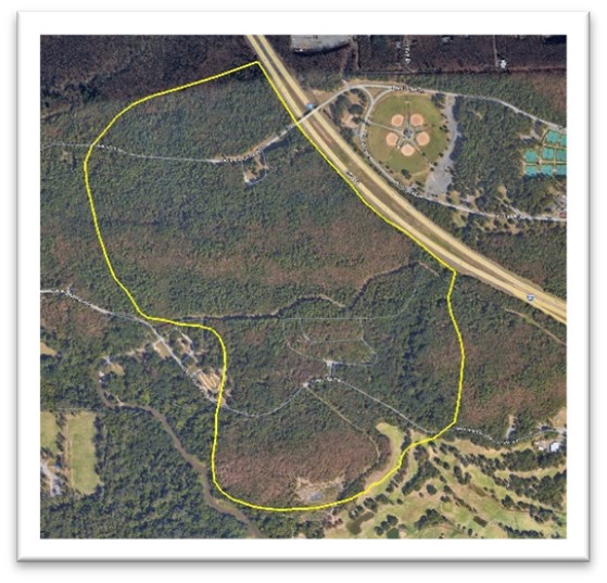
Burns Park Area 5 - Munitions Response Site location map

Remedial Action

Current status of cleanup activities and ongoing monitoring

North Central and Southeast MRS

At the North Central and Southeast MRSs removal activities have been completed and involved both surface and sub-surface MEC removal. Even after the removal efforts, potential explosive hazards may still remain within the target areas; therefore, an educational awareness program will be implemented for this MRS.

Ongoing Monitoring: USACE will re-evaluate the selected remedy every five years to ensure that it is still protective.

Burns Park Munitions Response Site

Burns Park (Pulaski County) is one of the key areas requiring Surface and Sub-surface Munitions and Explosives of Concern (MEC) Removal and Educational Awareness activities.

East Central MRS

In the East Central MRS, the remedy involves the removal and disposal of munitions remaining on the surface, which reduces hazards to potential receptors whose activities primarily involve surface use. An educational awareness program will also be implemented for this MRS.

Educational Awareness Program

The Educational Awareness program includes public education aimed at informing current landowners, commercial workers, and the public of possible dangers in the area.

Types of Munitions Found

Munitions and explosives discovered in remedial action areas

Munitions Found in Remedial Action Areas

DON'T FORGET: Munitions are dangerous and may not be easily recognizable. Never touch, move or disturb a munition or suspect munition. CALL 911

Location Information

Key roadways and geographic references for Camp Robinson areas

Key Roadways

  • Jones Road: Important access route in the area
  • Highway 89: State highway providing regional access
  • Interstate 40: Major interstate running between North Little Rock and Conway

Geographic Context

The former Camp Robinson FUDS is located east and north of Interstate 40 between North Little Rock and Conway, Arkansas, spanning portions of both Pulaski and Faulkner counties.

Current Land Use: Portions of the former camp area are now part of the Camp Robinson State Wildlife Management Area, while other sections have been transferred to various entities including private ownership.

U.S. Army Corps of Engineers - Little Rock District

Camp Robinson FUDS Site - Environmental Restoration

Protecting public health and safety through responsible investigation, remediation, and ongoing educational awareness programs.