us army corps of engineers logo - white castle on red background

Table Rock Lake 

Shoreline Management

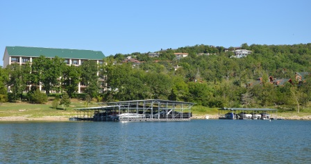
Resort and Boat Docks on Table Rock Lake

The primary objective of the Corps of Engineers in the management of the Table Rock Lake shoreline is to insure the general public full recreational enjoyment and fish and wildlife benefits on public lands and waters, both now and for generations to come. A Shoreline Management Plan (SMP) has been developed that is designed to insure maximum benefit to the general public while preserving project resources. See the links menu to the left for a map of the shoreline zoning allocation map in PDF format.

The guidelines below have been compiled in an effort to provide general information about activities permitted on government-owned land around Table Rock Lake. They outline the procedures required to apply for permits or licenses for various activities or uses of government-owned lands. Space does not permit a complete listing of all possible activities, but this discussion covers most of them. Complete rules and regulations governing public use of Corps of Engineers projects are contained in CFR (Code of Federal Regulations), Title 36, Chapter III, Part 327.

Shoreline Management Guidelines

Collapse All Expand All
 Shoreline Use Permits

Ownership of private land near the lake or adjoining government property does not convey any exclusive rights to use of the lake or adjoining public lands. An application must be made to the Project Office for a permit prior to construction of boat mooring facilities, alteration of government land, or modification of vegetation on the lakeshore. Shoreline use permits are issued and enforced in accordance with provisions of Title 36, Chapter III, CFR, Section 327.19. Non-compliance with the terms of the permit and the regulations will be grounds for revocation of the permit, and removal of the dock may be required.

A fee will be charged for shoreline use permits to help defray expenses associated with issuance and administration of the permits. The fee is $30 for a boat dock permit and $10 for a vegetative management permit. Where applicable Real Estate Fees may be applied. Both of these permits are valid for five years. All permits are nontransferable and non-refundable.


 Private Floating Facilities (Boat Docks)
  1. All approved private activities or facilities are only authorized in writing from the Corps of Engineers.   The type of written authorization issued by the Corps of Engineers depends on the type of activity or facility.  Shoreline Use Permits are issued for private floating facilities and are governed by the regulations in the Table Rock Lake Shoreline Management Plan.  Please refer to the plan for guidance on permits for boat docks ( pages 12-29).   If you have questions, please contact the Table Rock Lake Project Office at: (501) 340-1950.
 Vegetation Modification
  1. All approved private activities or facilities are only authorized in writing from the Corps of Engineers.   The type of written authorization issued by the Corps of Engineers depends on the type of activity or facility.  Shoreline Use Permits are issued for vegetation modification and are governed by the regulations in the Table Rock Lake Shoreline Management Plan.  Please refer to the plan for guidance on permits for vegetation modification( pages 29-31 ).   If you have questions, please contact the Table Rock Lake Project Office at: (501) 340-1950.
 Real Estate Instruments

Real estate instruments refer to leases, licenses or other legal grants issued for commercial or individual activities, which are not covered under Shoreline Use Permits. These activities involve construction of structures, including, but not limited to, masonry walkways, boat launch ramps and parking areas, roads, water lines and power lines. A written request must be submitted to the Project Office, who will make a recommendation to the district office. Each request for a license will be considered on a case-by-case basis. Assistance in preparing applications for real estate instruments is available at the Project Office.


 Project Boundary Line

Most of the boundary line on Table Rock Lake has been surveyed and monumented. Survey monuments placed at ground level define the boundary line. The survey markers are brass caps 3 ½ inches in diameter stamped to show the monument number, the year surveyed, and the agency, Little Rock District, Corps of Engineers, US Army. A 5-foot white steel fence post is set about one foot from the survey marker or monument, as an aid to location. Normally the project boundary is a straight line between survey markers. The elevations and distances between these survey markers vary. As an additional aid to locate the line, some trees along the boundary line are marked with a 4-inch wide white band. These trees, however, are usually off the line and only indicate that the line is nearby. Information is available at the Project Office to assist you in locating the boundary line.


 Flowage Easement

Flowage easements were acquired above the boundary line up to, as a general rule, elevation 936 MSL. A flowage easement gives the government the perpetual right to overflow privately-owned land, if necessary, during flood control operation of the reservoir. The government also has the right to impose building restrictions on flowage easement. Specifically prohibited in the flowage easement area are any changes to the land contours and any structures for human habitation, whether permanent or temporary. Waste disposal systems and attached decks are considered a part of the habitable structure and are also not allowed. Construction of any type on flowage easement requires prior approval of the Corps of Engineers. There are over 875 flowage easement tracts, consisting of more than 3,000 acres, located on Table Rock Lake. You can view a map in PDF format from the downloads menu located to the right on this website. This map only shows potential areas of flowage easement on Table Rock Lake.


 Hunting

Hunting and trapping are permitted on the waters and on the surrounding government-owned lands of the projects and are subject to all applicable federal, state, and local laws and regulations. Please refer to the Table Rock Lake Map for general locations of government owned lands. Officers of these same agencies will carry out enforcement. Hunting is prohibited in developed parks and other areas designated by the District Engineer and marked by the posting of appropriate signs. For a more detailed map of permitted hunting near the Cow Creek area, please refer to the Hunting Map Near Cow Creek

Permanent tree stands are prohibited on Corps of Engineers property. Permanent stands or steps are any type that penetrates the bark of a tree. Portable stands with the owner’s name and address permanently affixed are permitted. Stands are to be hung no earlier than one week before the opening and remain no longer than one week after the close of archery season.

The vast majority of bow hunting accidents occur from falling out of trees, please always wear a safety belt when using tree stands.

For more information on hunting safety, regulations, and licenses in Missouri, please contact the Missouri Department of Conservation and for Arkansas contact Arkansas Game and Fish Commission.


 Applications

Should you have any questions concerning an application involving shoreline management please contact the Duty Ranger at 501-340-1935. You may also visit the Table Rock Lake Project Office, located just south of Table Rock Dam on Highway 165, Branson, Missouri. Office hours are 9:00 a.m. until 4:00 p.m. (Closed 11:30am to 12:30pm for lunch), Monday through Friday, except federal holidays. Your interest and assistance in preserving the natural beauty and quality of the lake and shoreline will be appreciated both now and in the future.


Duty Room Contact

U.S. Army Corps of Engineers
Table Rock Project Office
4600 State Highway 165
Branson, Missouri 65616-8980

Phone: (501) 340-1935
Fax: (417) 334-4169
DutyRoom.TableRock@usace.army.mil

Monday - Friday
9 am - 11:30 am
12:30 pm - 4 pm